
Bendigo is a city in regional Victoria approximately 150km northwest of the capital Melbourne. Once a bustling gold-rush settlement littered with poppet heads, mullock heaps and the deafening soundtrack of stamping batteries, Bendigo has – thanks to its golden past – transitioned into an established and grand city.
Victoria’s recorded gold production is in excess of 2500 tonnes, which, compared to the all-time total gold mine globally of 190,000 tonnes, isn’t too bad hey? It is thought that the gold in Central Victoria came from deep in the crust, sourced from Cambrian Metavolcanics which underlie the entire goldfield, as explained by Ross Cayley in the video by the Geological Survey of Victoria below.
If you watched the video you will know that the most common rock type in all of Victoria – and it should be no surprise to you – is sandstone and mudstone. Otherwise called ‘quartz rich marine turbidites’ or the Lachlan Supergroup. And this tells you something about how they got there. They were deposited in a deep marine environment during arc formation – kind of like what is happening off of the coast of New Zealand, for instance.
The map below is interactive and can be used to navigate to a number of important landmarks around the city, as well as mining sites and outcrops of the underlying geology. All layers, including: geology, anticlines, faults, shafts and mines, can be selected or deselected and queried.
What you will notice above is that the sandstones and shales are all tightly folded into folds called anticlines and synclines and (folds, like waves in a carpet). The other important thing to notice thing to note is the predominance of shafts and mines – and therefore lines of reef – over or just east of the anticlines. This is Bendigo geology in a nutshell.
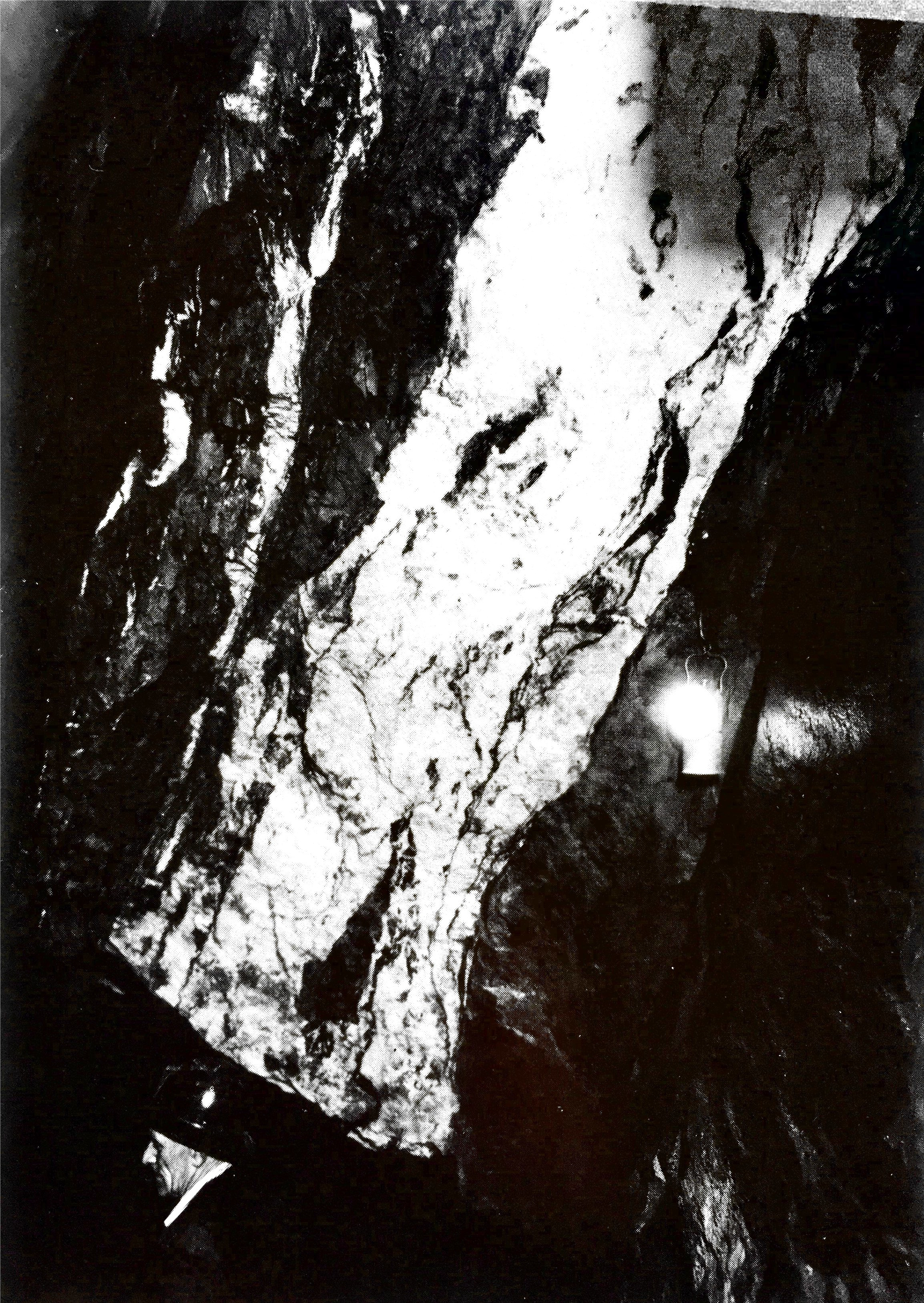
The diagram above provides a simplified geological history as well as a brief description of the different gold-bearing quartz reefs miners targeted. It’s hard to imagine the reefs depicted in the diagram above how they would appear in real-life. Below is a photo taken of a quartz reef at Central Deborah Gold Mine.
HOW DID THE GOLD GET THERE?
But how did the gold get there? To answer that we have to understand what an ‘Orogenic Gold Deposit’ is. Orogenic goldfields involve an orogeny. An orogeny is a period of deformation – large-scale shortening or extension of the crust.
The Himalayas, for instance, have grown to their enormous size because of shortening. Two continents have collided together, resulting in a collisional orogeny and mountain building. There are also accretionary orogens, where a rigid continent and oceanic crust have collided, such as what is occurring off the coast of Japan (imagine pushing the carpet against a wall, it crumples).
These large-scale deformation events produce a lot of heat and cause large volumes of fluid to be released from deeply buried rocks into the crust. These volumes of fluid, called metamorphic fluid, have carried the gold up through enormous Faults (such as the Whitelaw Fault in the interactive map above) and into smaller faults and anticline hinges during earthquakes, such as that depicted in the diagram above (moving from high pressure to low pressure).
GOLD MINING
The Victorian Goldfields is one of Australia’s major mineral provinces, with gold production in the region two orders of magnitude higher than higher than any other metal mined (>2500 tonnes). From the first discovery of gold in the Bendigo Creek with pans, picks and shovels in 1851, to the large-scale open-pit and underground mines which today operate in Victoria, the landscape of gold mining has certainly changed. This is a really oresome resource which can be used to understand modern mining: exploring, extraction, processing and exporting. Use it to compare with historic mining practices you can explore in Bendigo.
Before it became an historic gold field and city, Bendigo and the surrounding land was a large sheep station called Ravenswood Run. Two women – the wives of workmen – Margaret Atwood and Julia Farrell, are credited with making the first discovery of gold whilst washing clothes at the junction of Bendigo Creek and Maple Street in Eaglehawk. The pair are now commemorated by a sculpture in the main square (see in map above).

Within days of their discovery hundreds of diggers descended on the banks of the Bendigo creek and within a few months, up to 40,000 people had settled in the area. Diggers in Bendigo initially worked surface alluvial reefs, a secondary gold deposit formed through weathering of quartz into creeks. It is a case of luck whenever gold is found in creek sediments. Gold is heavy, so diggers used anything that could take advantage of this property to concentrate gold with tools such as pans and shovels (or kitchen bowls!).
As alluvial gold dried up (in just 3-4 years), some miners who had spent time in the Californian gold fields realised that the gold-bearing quartz which outcropped at surface was the source of the gold. Victoria Hill was the first area where miners sunk shafts to follow the quartz underground and find gold at depth.
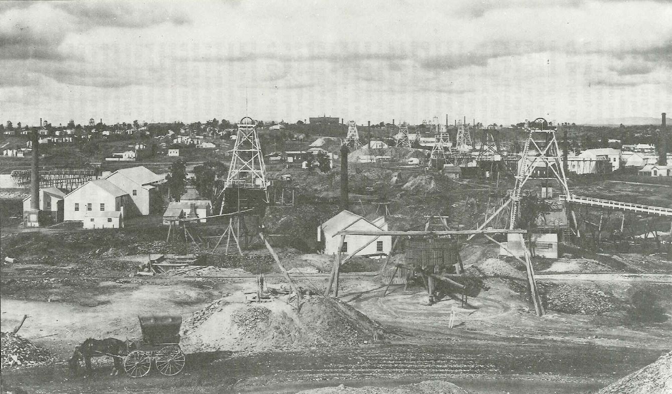
Forty percent of Victorian gold production has come from primary quartz vein deposits, and sixty percent from alluvial gold deposits. The Bendigo Goldfield contains 37 distinct gold-bearing quartz reefs that extend across an area 16km by 4km (the interactive map above shows these as anticlines). More than 5,000 registered gold mines were formed within that area. At least 140 shafts exceeded 300 metres in depth, 67 exceeded 600 metres and 11 were over 1,000 metres deep. The Bendigo goldfield represents the largest concentration of deep shafts anywhere in the world.
VICTORIA HILL HISTORIC RESERVE
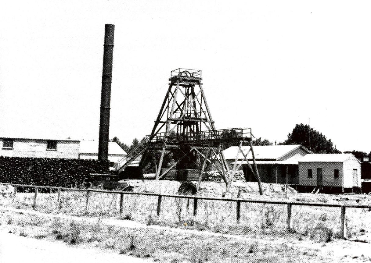
The best place to start exploring the gold mining history of Bendigo is at the Victoria Hill Historic Reserve in Ironbark. The area has historic diggings retaining artefacts and machinery spanning from 1854 to 1913.
The Victoria Quartz Company was one of the richest and the deepest nineteenth-century mines, reaching 1486m in depth and yielding at least 1,200,000oz in gold by 1861. Both surface alluvial and deeper quartz reef mining took place on the claims taken up on Victoria Hill.
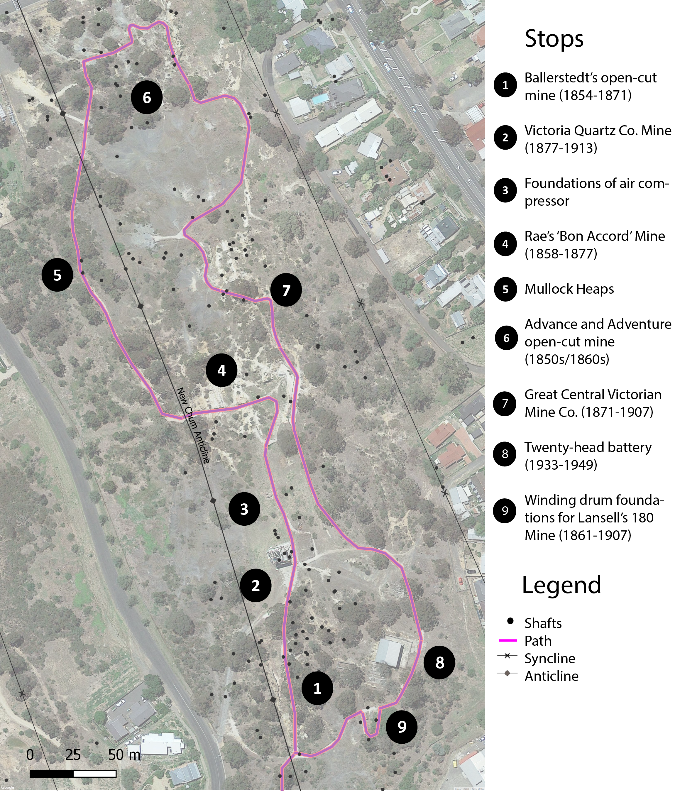
The historic reserve has a guided trail with plaques at the major stops describing the significance of the site or machinery.
The hill is at the heart of Bendigo’s mining history, connecting two prominent rags-to-riches businessmen: Christopher Ballerstedt and George Lansell. Ballerstedt and his son were Prussian immigrants, purchasing a number of claims on Victoria Hill. They established an open-cut mine which you can walk through at stop 1, as well as several shafts. Their success at sinking deep shafts inspired others to follow suit. Initially to crush the quartz they used crude horse driven machinery (not preserved at the site).

Their fortune steadily grew and by the late 1860s they owned a twenty horse power steam engine which powered their sixteen head quartz stamping battery. A stamping battery is used to crush quartz brought up from underground as part of the gold extraction process. There is an example of a much later twenty-head battery at stop 8. The pair also built Fortuna Villa, an enormous mansion just south of Victoria Hill (see interactive map above).

George Lansell purchased the mine, plant and house (Fortuna Villa) from the Ballerstedts – who were returning to Prussia – in 1871. He re-named their claim the 180, earning his fortune from the rich quartz reefs which continued to be struck at deeper and deeper depths. He is often cited as the ‘Quartz King’, contributing greatly to the development and preservation of the mining industry in Bendigo.
There are other mines from different eras which you can wonder through at Victoria Hill, including Rae’s ‘Bon Accord’ Mine at stop 4 and Advance and Adventure Open-Cut Mine at stop 6.

There are also numerous mullock heaps along the path at stop 5 – waste shales and slates used for road base, among other things.
CENTRAL DEBORAH GOLD MINE
Having explored the relatively in situ surface of mines on Victoria Hill, Central Deborah Gold Mine should be your next stop – to actually go underground. The mine was established as a tourist mine in the 1980s after excavation of shallow underground levels two and three) to create underground experiences.
Many of the buildings currently located on the surface of the mine are original and would have been used by miners and other contractors, including: the ‘clean’ and ‘dirty’ dressing rooms (heated by the boiler), first-aid room, carbide light room, mine-manager’s office and carpenters workshop/garage.
The Central Deborah Gold Mine operated from 1939-1954 and during that time employed 375 male miners who successfully extracted almost one ton of gold (929kg) from the ground, which would be worth about $52 million in today’s prices.
The objective of the mine was to locate the continuation of the ‘inner reef’ which had already been mined successfully along the Deborah line at the Deborah Mine. At its peak, Central Deborah reached a depth of 412 metres. It has 17 separate levels and 15 kilometres of drives and cross cuts (tunnels).

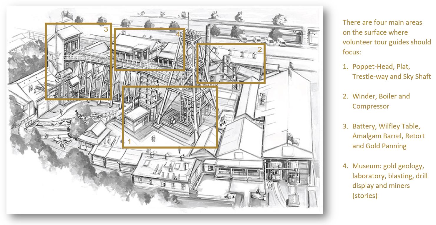
There are four experiences offered at Central Deborah: a self-guided surface tour; an experience tour where you are able to trace the original tracks of the ore carts in level 2, viewing a drill and blast, bogger and rock drill demonstration; a level 3 underground tour and, the ‘Nine Levels of Darkness’ tour.
The poppet-head is the main draw-point of the surface tour. Like most plant at mines in the Bendigo goldfield, the poppet-head moved through many different mines before settling at Central Deborah, including: the Catherine Reef Company at Eaglehawk and the New Red White and Blue Consolidated Mine at Golden Square. The height from the top deck to the ground is 22.5m. The flag on top is the ‘Bendigo Flag’. The mine’s shaft is timbered into four compartments, two centre compartments for the cages, a smoke-box and a man-way with ladders.
Each shift would sink one half of the shaft, firing at the end of the shift. Once fuses were lit with fuse lighters, the shot-firer would climb out to safety using the ladders. The following shift would ‘bog out’ or remove the loosened stone and repeat the process again. Ore was brought up from underground in ore trucks like those on display at the base of the Poppet-Head. The trucks would be raised up the sky-shaft by the winder to the first level, called the landing brace. A brace-man would receive the truck and if it was waste rock (i.e. shale or sand-stone), wheel it down the trestleway to tip on the waste- or mullock-heap. If it was ore, it would be passed into the mill.

Both mechanical and chemical processes were used at this mill. The stamper battery is fed by a feeder at the back which separates the quartz evenly amongst the stampers. The stampers are each 523 kg in weight, powered by an electric motor, falling 94 times per minute.
After passing through the stampers, the ore forms a thick slurry with particles as fine as beach sand. In the battery box, it passes through a mercury bath before continuing through perforated screens at the front of the battery box. Mercury and gold attract and form an amalgam (clump). The slurry flows onto Copper-plates coated with acid and mercury, to further amalgamate with any gold.
The mix then washes over grooves called corduroy strakes as well as a blanket table. This is a final trap for gold which takes advantage of its high density, using gravity to capture fine gold in grooves. The powder and water is then washed over a sloping vibrating table called a Wilfley table where sulphides such as pyrite are collected and left-over sand is washed into a heap. Sulphides contain 2-3% gold in their crystal structure which can be recovered using Cyanide and heat.
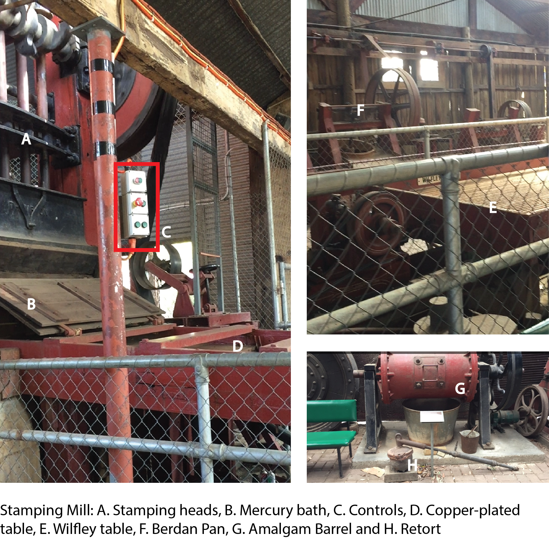
The amalgam is then combined with bits of old steel into a large metal drum called an amalgam barrel. This barrel is slowly rotated for up to 16 hours. This ensures that the gold and mercury is fully combined.
The Gold-Mercury amalgam is placed into a clay container called a retort. The retort is completely sealed. This is because the retort is placed on a fire or in a furnace and heated up to greater than 357ᵒC, which is the vaporisation temperature of Mercury (for Gold, this is much higher).
The vaporised Mercury flows along the pipe and at the point where cool water is introduced into the system, becomes a liquid again. It is captured and returned to the battery. The gold – now a neat cake – is then collected and taken off to the nearest bank by the manager to be exchanged for cash.
We acknowledge the the Dja Dja Wurrung Peoples of the Kulin Nation as the Traditional Owners of the land upon which this field guide has been created. We recognise that many areas hold deep cultural significance for local Aboriginal groups and we hope you will keep this in mind as you explore the region.

Leave a comment