
Structural geology is a geologist’s primary tool or language which he uses to observe and describe rocks – from the microscopic (i.e. crystallographic structures) to the macroscopic (i.e. faults and folds), and even to global scales (i.e. tectonics). Studley Park, just outside the Melbourne CBD, is the perfect place to learn some of the basic concepts of geology.
As you can see from the map below, the park is literally littered with trails and paths that wind through all of the natural vegetation, taking walkers to well maintained picnic areas, waterfalls and picture-perfect sights over impressive viewpoints. The park can be accessed via Yarra Boulevard or Yarra Bend Road (Figure 1).

The oldest rocks in the park are Silurian (~400 million years) in age. Layers of sandstones and interbedded mudstones termed the Dargile Formation (tan coloured in Figure 1) were probably deposited on an ocean floor in deep water over 100s of 1000s years. Mudstones generally indicate still water conditions and sandstones indicate a high energy water environment – think of the river vs beach! For a nice explanation of this see this Museum Victoria video featuring Ross Cayley.
Geologists use many different methods to estimate how old rocks are. At Studley Park, fossils called graptolites were used. Graptolites are very useful dating tools because they often have a worldwide distribution AND only occur for short periods of time. This helps us to correlate rocks in say Victoria, with rocks in England – and nail their age. Other fossils occur in the sandstones at Studley Park, including: brachiopods, gastropods, corals and trilobites – but you’d be extremely lucky to find them! I’d advise you not to try, as you’d probably destroy some of the outcrops.
Unlike the image above, however, you will notice that not all of the interbedded sandstones and mudstones are horizontal – in fact many are vertical! How does this happen? Folding and Faulting. Compression (i.e. pushing together) about 380 million years ago buckled all of the originally horizontal beds. I run through folding in my guide for Werribee Gorge.

There are many excellent outcrops at Studley Park where you can see folds and faults up-close-and-personal. You can start the walk from either side of Yarra Boulevard – I started on the small steep trail which leads to location 1, but you can also start from near the bridge at location 6 and give location 1 a miss. There are many smaller trails – some dirt bike trails- that wind around the park. If safe, go explore them! My trip was cut short because of rain, but I’ll be back later in the year to look for more outcrops.
We’ll start with location 1. This was a bit difficult to get to (I wouldn’t encourage young children climb it), but you find the trail after the big descent from Yarra Boulevard.
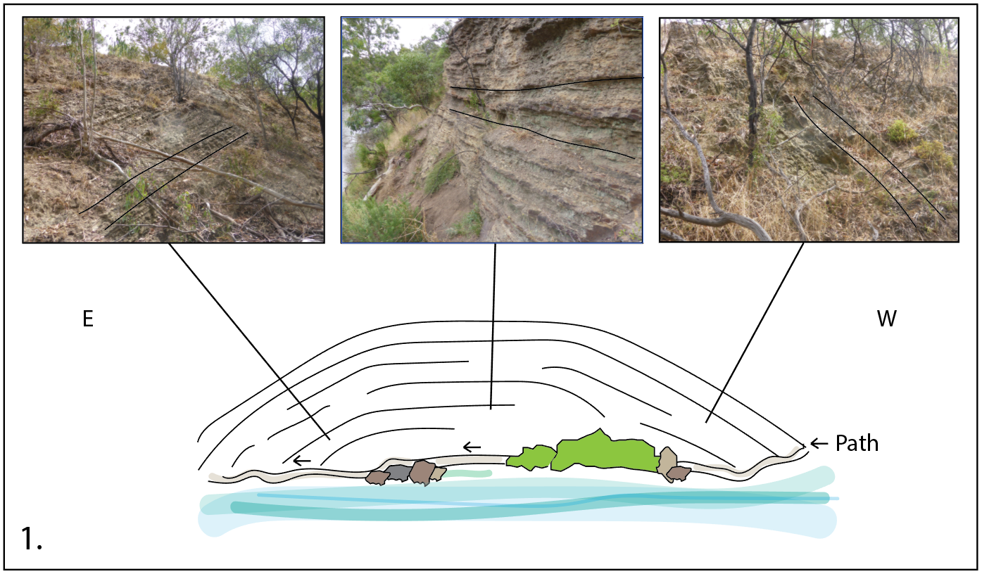
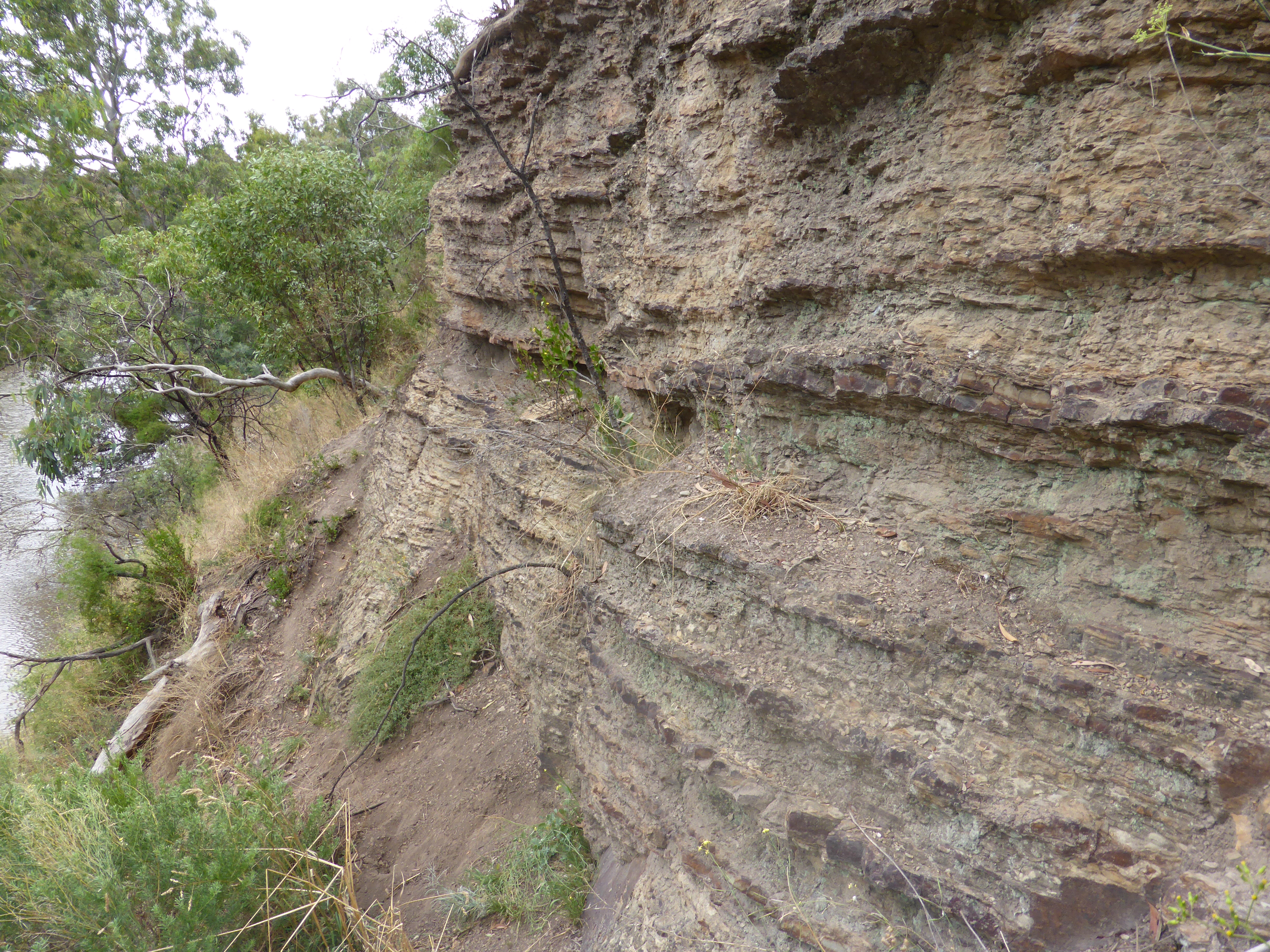
As you work your way around the path by the river you’ll notice the dips of the beds change. The easiest explanation for this is a big open fold (we’re a big fan of Occam’s Razor in geology). This is probably the most open (as opposed to tight) fold I encountered in the park.
Work your way back to the trail and head down the long grassy path up towards location 2 at Dight’s Falls. Here you’ll encounter – at least from a distance – the other major rock type – basalt (red in Figure 1) – which covers all lowland areas. From ~4.5 million years ago Melbourne became a dangerous place to be, with a number of volcanoes active (I explore the Newer Volcanics in more depth at Organ Pipes National Park).
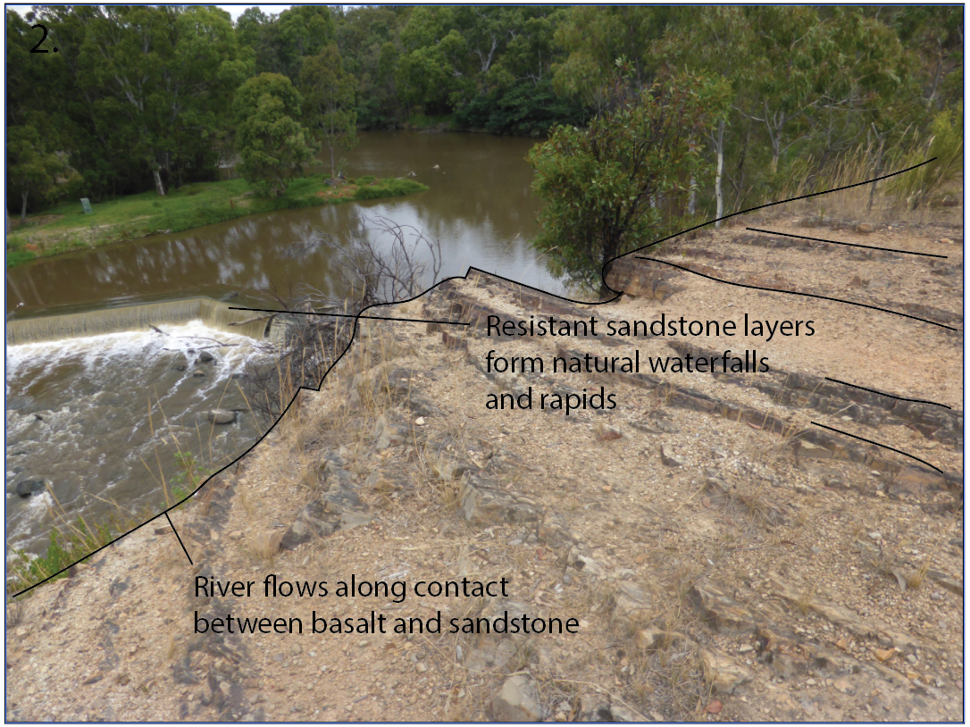
Flows from a volcano which erupted around 2.2 million years ago flowed down the Merri Creek, with another flowing down Darebin Creek around 800,000 years ago. The cliff you are standing on represents the junction between the Silurian mudstones and sandstones and the Cenozoic basalt on the opposite side of the bank. The difference in height has occurred because of weathering – it is a lot easier to erode basalt than it is lithified sandstone!
Continue following the path around to the back of the ridge. All of the other localities are along this path.

When you first encounter the tall cliffs on your left, don’t just pass by without giving them a close inspection. In the image (location 3) above it might just look like your average vertical beds (these are old news by now :P) but in actual fact, there are very important younging indicators. Younging is a term geologists use to describe the direction in which straigraphy (all of the sandstone and mudstone beds) become younger. Ripples preserved in sandstone or mudstone can indicate which surface was originally on top (affected by waves).
This also helps us to figure out if we are in a synform (‘u’ shaped fold) or antiform (‘n’ shaped fold) – like those which you will encounter at locations 4, 5 and 6.

This fold at location 4 is asymmetric (inclined rather than straight like corrugated iron), narrow (rather than open like at location 1) and affected by faulting in its west-dipping limb (red dotted line). When you fold beds this tightly, a problem of space can arise – especially when some are thick sandstone (competent) and others are thinly bedded mudstone (non-competent).

As you can see at location 5, the thick sandstone beds stay the same thickness all around the hinge of the fold (we call this ‘parallel’ folding). The mudstone beds, however have deformed or squeezed from the limbs into the hinge forming a ‘cuspate’, ‘isoclinal’ geometry. Think of layers of a cake, one with a lot of thin slabs of sponge separated by cream. When you take a bite out of the cake and ‘squish’ it, the cream might squirt or fill spaces, whilst the sponge will probably crack.
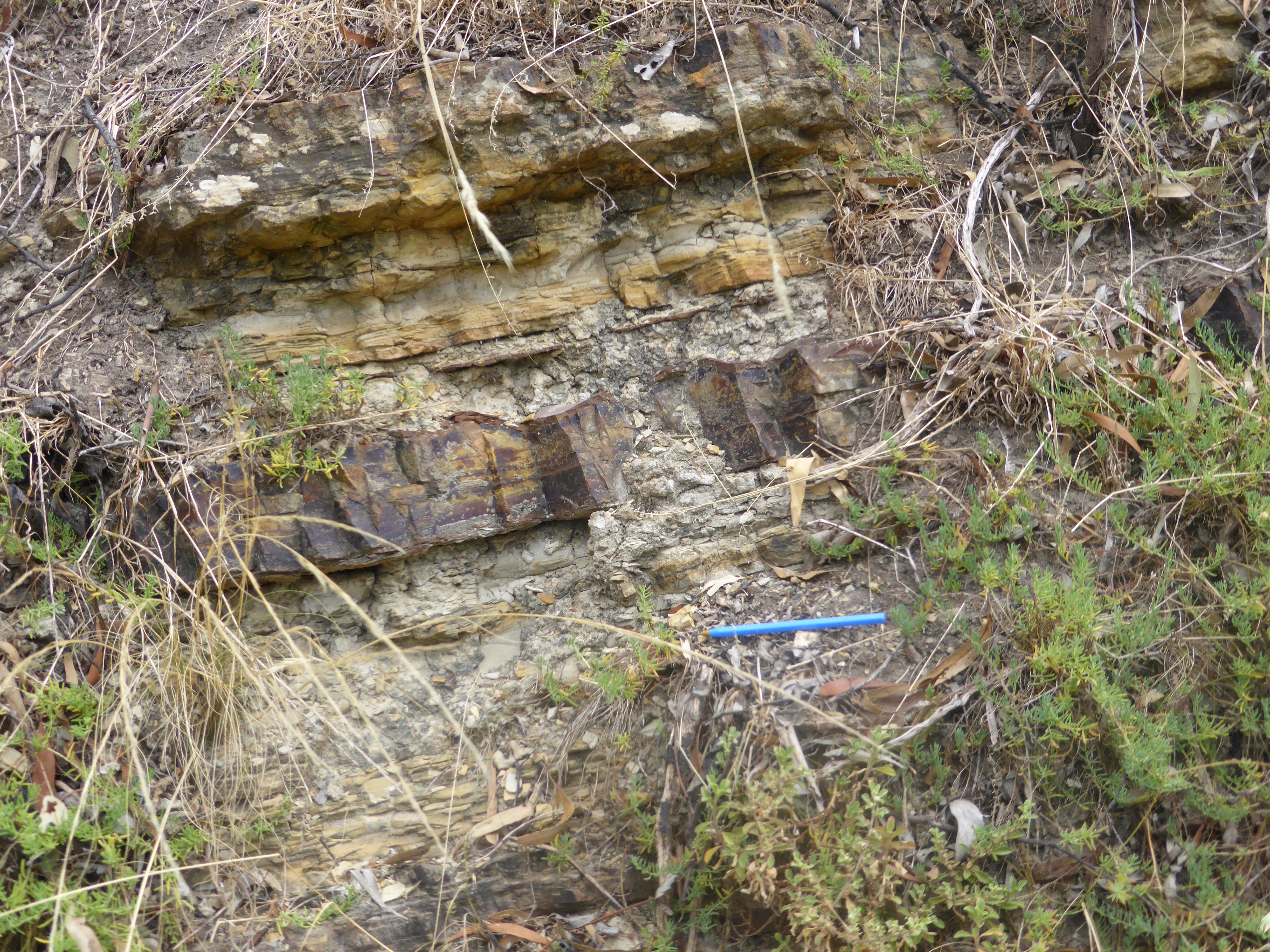
Another way in which space can be accommodated is by faulting. At location 5 there is an east-dipping fault which offsets the thick sandstone bed vertically. The faulting probably took place shortly after folding. You can also see at location 5 that the thick sandstone shows a lot of cracks – which we call ‘joints’. There are two joint sets – one parallel to bedding (goes around the fold) and one perpendicular to bedding (sub-vertical).
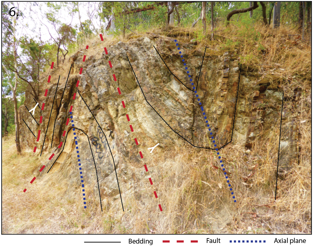
Location 6 was probably my favourite – so I’ll give myself permission to nerd out on it a bit. It shows (from west to east) east dipping beds which are younging up truncated by a steeply west-dipping fault. At my mine we would call this an ‘oblique-parallel’ fault. The steeply west-dipping bedding is bound in the east by another steeply west-dipping fault with vertical displacement. In the footwall of this fault (underneath) is a truncated east-dipping asymmetric anticline. East of the anticline is a syncline, which is also east-dipping and separated from the anticline by a steeply west-dipping fault.
For more detailed information regarding the BBQ and picnic facilities, please see the Parks Victoria park notes.
We acknowledge the the Wurundjeri Peoples of the Kulin Nation as the Traditional Owners of the land upon which this field guide has been created. We recognise that many areas hold deep cultural significance for local Aboriginal groups and we hope you will keep this in mind as you explore the region.

Leave a comment